Čeština
 Deutsch
 English
Jiří Rak’s trip recommendation
Some of the data may not be current, thank you for understanding.
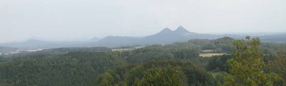
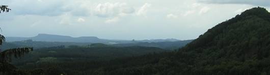
 One of the most beautiful trips to Růžák and the mesas of Saské Švýcarsko begins with a small road leading from Polevsko to Prácheň. The Lužické Hory open up a lot of similar views, splendidly caught in pictures of nature taken by Mr. Stejskal from Jiřetín pod Jednovou. One may easily get to the view by car. However, it is better to walk along the road and take the trail marked with blue signs. First off, you will see the beautiful Klíč pyramid, proudly rising above the cottages of Polevsko. Then you will discover the beautiful organ-like basalt structures in the abandoned quarries on the Polevský ridge, and, after that, you will be engulfed in the present panorama of Zámecký hillock, Studenka and other landmarks of our region, beautiful in every season. The winter scenery of this place has a once-in-a-lifetime atmosphere. Snow exaggerates the sharpness of the volcanic cones and muffles the view over the many meadows. You will come up to the parking lot at Panská skála – its columns black against the white background. This non-demanding trip still shows you views that you won’t see within a thousand kilometers.
 Many visitors are not so interested in visiting the famed gorges in Kamenice at Hřensko. It used to be the pearl of České Švýcarsko but now has lost much of its charm due to the crowds of visitors and long, drawn-out lawsuits, which will not be the subject of this column...
However, it suffices to remind us that our precious Krásná Lípa is primarily the gate to the valley of Křinice, which is no less romantic and yet not often visited by tourists (Making an exception, of course, for the cyclists in the Kyjevské Valley). In the most beautiful part of the stony passage, we can find a place where it is possible to sail a boat. It is also a place that belongs to the best objectives of Českosaské Švýcarsko, thanks to its quiet, captivating beauty and, for many, it surpasses even the charm of the afore-mentioned gorges – unquestionably for me.
The best way to get to the Krinická gorge from Brtníky is to follow the blue signs through the old hamlet Kopec, with its well-preserved Upper Lusatian houses, through the valley of Brtnický Brook and finally along the Křinice towards Zadní Doubice.
From here we can go along the German side towards the old, half-timbered mill, Niedermuehle. It is one of the most beautiful solitary houses of the rocky landscape, right at the Křinice. Nowadays, it is not functional, but it still fully retains its allure of old for hundreds of years. In vain the ruins of Dolský mill recall this charm, despite all the care; the mill itself is an unwelcoming and uncomely place.
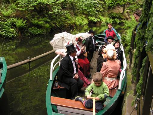
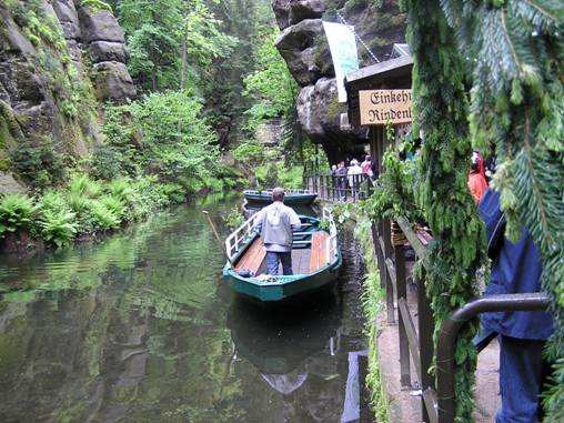
Presently, the red marks lead you further to the dark and deeper rocky ravine, to a small lake, Obere Schleuse, that arose centuries ago and was used to drive logs along the Křinice river, towards its mouth to Elbe in BadSchandau. Here, one can find a small quay and a little, cozy restaurant, set beneath the rocks right next to the water. The boatman will tell the visitors, in German of course, about the history of the town and how the small lake has been used for sailing for more than 130 years. We can only be enchanted by the enthusiastic, calm cruise along the old borders between Czechia and Germany.
It is a good nine kilometers from Brtníky to the gorge, but if you set aside the whole day, you won’t be disappointed. For those who are not forced to return the same way, two options are offered:
From the gorge climb up along the marked paths to the high-placed village of Hinterhermsdorf and continue towards the observation tower on Weifberg and to Mikulášovice. It is a different world, mountain landscapes, and forests.
Or one can walk along the Křinice up to the former Zadní Jeřichovice from where you can cross the border into Czechia and follow the green marks to Tokáň and Mezní Louka. That would be, however, for a whole different story.
And so, Krásná Lípa is a starting point for a great hike that surpasses the beauties of Hřensko. Keep that in mind and go to the gorges of the Křinice more often with friends. It is your river that, not far from your town, creates one of the most remarkable valleys in Českosaské Švýcarsko. Promote more of these places in your region – you have something to be proud of.
 An unbelievable 40 years ago, in the spring of the gray year of 1969, at the time when Czechoslovakia was experiencing severe standardization, I first walked in the rocky landscape of České Švýcarsko. A two-month stay in Jeřichovice with the opportunity for many outings was a significant break in the life of this twelve-year-old boy. Since my childhood, Father would take me on trips into Czech Paradise or Kokořínsko. The sandstone enchanted me with its winsomeness, but České Švýcarsko surpassed my expectations.
Tourism was not as excellent as it may be today – we could not cross the borders – but still, some things functioned that no one can renew. In the Lower Pass (Dolní soutěska), it was possible to visit a stylish, excursion restaurant, that remembers the beginnings of tourism. From Hřensko to Děčín, you could voyage on an old, authentic steamboat, in Hřensko you felt as if in a spa town. To the right is the gate to České Švýcarsko and at the hotel in Mezní Louka, you could eat in a well-run, self-service restaurant from 7 in the morning long into the evening. This is ideal for tourists who do not want to wait an hour for food. Unfortunately, Hřensko has long since lost its touristic glory and charm (today, one is afraid to lead visitors through here, so that he does not dissuade them from visiting the rocks).
A few years later I had already walked the length and the breadth of the rocks and gorges. The landscape had no limits for me. I spent one September night under the stars among the rocks of Růžová Zahrada. The deer in rut echoed in the deep valley beneath me, and I felt like I was on the top the whole world. Since that time, I have brought people to these places that were closest to my heart – over the years, except my wife and children, there have been only six...
The next morning surprised me in the gorge along the Křinice. I was scraping through the footpath along the borders with DDR (The German Democratic Republic), going up steeply by Velký Kozí mine, then immediately descended towards Velký Zschand. And again I went up along the ravines and along the upper edge of the Křídelní wall up towards Pravčická Brána. For me, those were the most beautiful outlooks, the most beautiful borders. The day ended in old Hřensko. I will never forget that beautiful Indian Summer.
Today, the House of České Švýcarsko in Krásná Lípa has become an important gateway to the rocky landscape. A few years ago, many people had their doubts. Today, more and more people begin their journey through České Švýcarsko right here, in a flourishing town on the upper Křinice. The unique display is unparalleled. Secretly, it wakes the desire in the visitor to set foot into the rocks and discover their world. The increasing number of tourists has, unfortunately, also one negative aspect. The narrow road from Chřibská to Jeřichovice is not built for such traffic. Luckily, a new bus line from Krásná Lípa to Děčín – having been commissioned only a few years ago – has brought huge improvement. We can count that as one of the greatest successes of the České Švýcarsko charitable trust. From the bus stops, we can directly step into the secretive ravines and wander there the whole day.
No longer as freely as I once did, but we can enjoy the fact that the National Park brings other values...
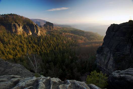
 The dominant mountain of Českosaské Švýcarsko has no equal: the massive hillside is made of basalt, which, as glowing magma during the era of volcanic activity, perforated the sandstone slab. Its remains create today's many kilometers of rugged, isolated tableland, with its border walls furrowed by the numerous, nearly inaccessible, ravines, sloping down to the Elbe Valley through the Schrammsteine rocks. Then, further to the valley of Křinice through Affensteine and the Baerenfanwaende rocks to the East, towards the valley Velký Zschand in the area of the Partschenhoerner rocks, and to the south in Czechia, through the Silver walls along Pravčická Brána and Křídelní wall.
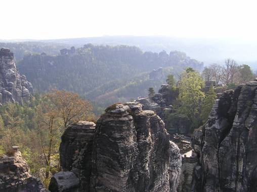
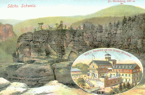
Even though the Czech section of the rocks represents just a small part of the jagged edge of this block, Pravčická Brána is one of the most significant geological formations in the whole Winterberg area.
On the German side of the mountains, we can find a lot of smaller, rocky passes, especially the numerous, magnificent rocky towers that connect the paths leading to the perimeter of the rocks which are, in many of its floors, freely accessible to tourists. Amazing are the passages at the Přední Loupežný castle with the cave Idagrotte, the Via Ferrata at Dlouhý Roh in the Affensteine rocks or the Krakonošovy Schody in the direction from Schmilka.
We can enter the rocky plateau and the Winterberg peak itself from the direction of BadSchandau or Schmilky in the Elbe Valley, or even from the valley of Křinice.
The famous touristic trail, Fremdenweg, leads us to Lichtenhain waterfall along the natural arch, Kuhstall, to Malý Winterberg. Here astounding outlooks open before us from Gleitmannshorn at the stony promontory Winterstein (Zadní Loupežný castle) Teichstein, Kanstein, Vlčí Hora and Jedlová (at night one can see the lights of cottages on Kamenná Horka!!!), and the summit of Velký Winterberg.
Until 1945, this major pathway led even further to Pravčická Brána, which tourists first saw from a dizzying height from the western side. This path was made unusable by the state borders between the two fraternally socialistic countries. In the new period after the national park was established.
Direct access to Winterberg from the Czech side has not been possible for many years, but it is still worth seeing. Certainly set off for it on one of the German pathways. There is a well-maintained hotel right on the peak that has, from the 19th century, belonged to the oldest touristic facilities in the area. Trendy and efficiently furnished rooms allow you to spend the night at the highest point in Českosaské Švýcarsko on the right bank of the Elbe.
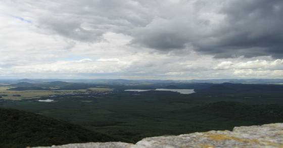
A recently reconstructed lookout tower offers us a unique view to the east on rocky peaks of Saské and České Švýcarsko like no other observation tower. You will see the Jeřichovické rocks and forests around the Křinice, Tokáň, Lužické Hory, and even the Krkonoše mountains from a very unusual point of view.
The outlook is not exactly circular, as it used to be; The outlook's field of vision – ranging from the north, covering the east, and ending towards the south – is today less than 180°. The peak is covered by an unparalleled, beautiful beechwood forest. It reminds us of the protected beech trees inJizerské Hory on Divočák, or in Lužické Hory on Velký Buk or at Pěnkavší Vrch.
To see to the west from the outlook, you have to go to the rocky spur Kipphorn, about a kilometer from the peak along the marked trail. The rocks offer a panorama of mesas, the valley of Elbe at Hřensko, and BadSchandau. Like a fan, the rocky region opens before us from the hollow at Schmilka and Schrammsteine. Dominating the sight in the background are Lilienstein, Zschirnstein, Děčínský Sněžník, Buková Hora and Milešovka.
The most beautiful view from Kipphorn is at sunset when there are not so many tourists. It is an ideal place to search one's heart or begin a great relationship.
The sun slowly sets, and a casual passerby does not want to disturb the enamored couple (or maybe he brought them here?). Rather, he descends alone to Schmilka, the old buildings are covering themselves with the darkness, a calm wind blows from the Elbe, and the walk along the road to Hřensko is not so in.
 Unjustly neglected is the tableland known of as the Verneřické Středohoří, which spreads from Děčín to Ústí k Ústěku. It has, of late, not been visited so often. In this seemingly unattractive landscape, the railway was decommissioned, save for the train station in Zubrnice, which has remained preserved as a museum. Many of the trails are no longer marked.
After years of decline, Děčínská Lodge on Buková Hora was restored, thanks to the incredible enthusiasm of a married couple called the Andoks. It is found near a television transmitter, and it could return at least some of the fame of the past to the place and the whole region.
Buková Hora (638 m a. s. l.) is one of the great destinations of northern Czechia. Only a few minutes from the Děčínská Lodge is the newly restored Humboldtova outlook, which offers us a panoramic view from Sedlo to Milešovka towards Krušné Hory, down deep into the Elbe Valley and on the agglomeration of Ústí nad Labem. In Děčínská Lodge, as you refresh yourself, you can read some of the articles about the history of discovering Buková Hora, carefully preserved by the Andoks. The touristic tradition of the place is longstanding, and the number of tourists could be compared to more famous destinations around Českosaské Śvýcarsko.
You can get right below the summit by car through Verneřice and Příbram. It is surprising how many of the inhabitants of Děčín or Ústí have never visited the place, or rather have never heard of it. Touristic pathways are sometimes hardly passable and lead from Těchlovice, Malé Březno, and Zubrnice. The scenic often opens up to very similar sights like the ones at Malá and Velká Fatra above the Váh Valley in Slovakia.
If you decide to set off and go through the ridge meadows towards the new outlook at Náčkovice, a great view of Růžák, Lužické Hory, Ralsko, and Ještěd will open before you. There are many outlooks like that in this area; however, it is crucial not to rush.
In Děčínská Lodge one can find accommodation. A few small, but pleasant rooms are ideal, even for family gatherings. From here you can set off to other destinations in the area, for instance, the ravine of Bobří brook with a waterfall, to Vrabinec, with a profound view over the Elbe, to an open-air museum in Zubrnice or the newly built observation tower on Strážný Vrch – another place that deserves superlatives, as far as the lookout goes. The scene, which includes the broad basin of Ploučnice to Růžák and the mesas of Saské Švýcarsko, Vlčí Hora, Studenec, Klíč, Hvozd, Českolipsko, Ralsko, and Ješted, is unique.
Only the vanished villages are forever lost. The whole area is very thinly inhabited, and so we have to discover its beauties at the beginnings of tourism. Despite the scarce touristic infrastructure, the area is worth exploring. Děčínská Lodge can become an excellent base for further discovery of the surroundings and a reminder of the bygone glamor of its visited destinations. The Adoks have been taking care of the lodge since 2003, and so we can admire the beautiful lookouts as, for instance, Kaiser Joseph the Second or the naturalist Alexander von Humboldt did in the past.
 The last Sunday in February caught me in the fields beneath the mysterious Castle Houska. It was evening, kind of like the first of May – the Sun was bending down to the west around five o’clock, but it was still quite warm. The warmth of the month of May that opens a time of joy, hope, and expectations. In the springtime we think, more naively than at any other time, of those we are attracted to, and we believe that we will encourage even a grain of attraction towards us to take root in them. Regrettably, that never happens, and so our earthly pilgrimage does not always express the facts of our deepest hidden friendships, desires, loves...
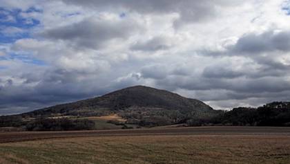
The road was descending to the ancient village Kruh and, above it in the distance, Bezděz, the key to Northern Czechia, was slowly rising.
Our landscape does not have a natural symbol that is more significant: the lonely mountain, visible from far away, the mountain-guard, mountain-castle, the magical beauty of the place's security, yet it is still coldly unconcerned. Mountain-defiance. It has ever drawn me near, and this time, it was doing the same thing; as if it was replacing the unheard desires of my soul. Secret wishes, pilgrimaging through the scenery of the poet Máj, are unfortunately always deluded and deafened by dismal thoughts.
I will not find such landscape in Czechia, where beneath the vast sky, enthused about the supernatural view of the mighty mountain with two peaks I forget about the practical life of email communication that, for the moment, has not engulfed me with its quickness and abbreviation. Behind it, hidden among the conical peaks of the Česko-lužický sandstone mountain range, are other mountain–castles like Ralsko, Sloup, Tolštejn, and Ojbín.
The western horizon darkened, far away lands lit up, and the magical peak was still clearly outlined above the pine groves, its raised pride bringing to mind Saint Michael Mountain on the faraway Norman shore.
Long into that evening, my joyful spirit did not abandon me. The doubts of my heart were overcome by the power of my spring journey. If only I could harness this moment, keep it within me and draw from it during the less happy days – the regal Bezděz was nearly invisible. The darkness covered the crown of the Czech lands; quietly, slowly, with the hope of future returns.
 Another magic mountain of Northern Czechia is similar to Říp, the highest peak of the Máchův region. The beautiful rocky terraces line the west hillside. Three levels of those terraces are unique among our sandstone formations. The rocks are similar to the ones beneath Winterberg or the Silver Walls. The pathway goes between the second and the third level of the terrace. The cone of Ronov and the old castle are remarkably easy to reach.
On the gradual peak, the slender beeches rustle; there is no outlook. The remains of a triangular tower have not crumbled, even after thirty years. The outlook on the Středohoří opens to the north from the clinkstone rock on the yellow-marked pathway, which surrounds the peak.
I am alone in the landscape, away from the land of people, away from the world full of artificially created problems.
The mysterious Vlhošť is quiet. The silence, however, is not indifferent. It embraces you if you are willing to break away from ordinary living. Nothing else is important now.
You walk out of the forest at an old gamekeeper’s lodge beneath Vlhošť. Beautiful meadows are towards Holany and Pavlovice. The observation tower shows us the Lužické Hory and Ještěd. It is a terrifying contrast: in the foreground, there is this wall of an apartment complex is Česká Lípa rising and dominating the surrounding basin. It is one of the ugly views of the Czech north.
Now descending to the holanské ponds, we are embraced by this quiet beauty. You can continue through the sandstone valley, called Peklo, where there are thousands of snowflakes in the spring, along with the Martinská wall to Dubá, or towards the wondrous Helfenburg castle, close to Úštěk. Surprising sceneries: they are so similar to the back part of České Švýcarsko.
 Sometimes you do not have to travel far. Beyond our backyards, we can discover places where we feel the energy of our beloved region, more intensely than on the faraway hilltops or in the tight, stony ravines, where we love to walk along the famous touristic pathways.
The gloomy autumn days, when the brown leaves huddled up on the paths around old cottages only hesitantly tell of the bright days of the forgone summer, sharpen our perception of the closest surroundings. The short day does not favor long hikes and so the old pathway to Kyjov over Kamenná Horka offers unexpected vistas, which we would never appreciate in a hurry, or we regard them as not dramatic enough.
Cottages crowd on the edge of the forest as if without life. Indeed, many of them remain deserted during the winter. The old trees, with their bare branches, know well that the winter and frost are coming soon, and so they hunch towards the pale Sun that will not warm them. Maybe, just now, we will realize the significance of Kögler’s trail and the importance of preserving the regional traditions. Until recently it never occurred to me to walk its nearest parts from the city graveyard over Kamenná Horka towards Vápenka and Maškův Vrch.
And so just recently, after so many years, I have appreciated the long-standing effort of Václav Heike and his tourists. I found, on a the cold November evening (at the sight of one shallow basin, in which, among the slopes, was a spread out Krásná Lípa), that Kögler's trail was not only renewed, but also as of late lead over Kamenná Horka and its surroundings all the way to the square in Krásná Lípa. With that, they created a combination of a short walking ring of pathways between Kyjov, Krásná Lípa, and Vlčí Hora. All in the dreamy countryside that speaks conspicuously to the lone pilgrim, quietly, not liking big, noisy tourist attractions.
Near the last cottages, a new view opened over the desolate meadows to Kyjov, on the silhouette of Vlčí Hora as it disappears into the foggy mist, and also onto the dark forests lying across the Lužické Hory to the sandstone relief of České Švýcarsko. It was cold. The November snow was falling in silence from the steely sky and hastened the evening’s arrival.
With surprise, I remembered, how four years ago, on this lofty part of the meadow behind Kamenná Horka, a group of young people performed a rather successful theater. We could call it “An Outing with a Picnic in the Year 1905”. It was a September, one hundred years after that year; the girls wore old, wide skirts and blouses, and the gentlemen assisted, dressed in the most bizarre hats that they had dug up only God knows where, preparing all sorts of delicacies, spread atop on a large blanket in the middle of the meadow. The warm and bright evening enabled the onlookers to observe the sunset during this play, the cottages on Kamenná Horka certainly looking on in wonder as to the meaning of it all.
It was not a return of the old times, it was not even a time of great entertainment. The young people than in a short period, and with great fervor, extensively and openly, working with other citizens of Krásná Lípa and people living in the settlements around Köllinger’s Trail, opened up Krásná Lípa and her surroundings to tourists, they opened the beautiful gate from the east to České Švýcarsko.
I was descending the old meadow to the Fibochovo Valley, it was no longer snowing. I did not look back to the scantily lit cottages of Kamenná Horka. Those four years are already forgotten; it is not necessary to return to the recent past. Without them, there probably would not be as many good things about the town and the region. Time is professional, managerially perfect, and cannot afford such sentiments looking back.
 I do not want to force my favorite places on the border between Šlunkovsko and the rear of České Švýcarsko on you, which were once famous in the times of pre-war tourism. If you have some other plans for autumn evenings, you can stop reading. However, if you have ever felt the quiet beauty of the ravines beneath Brtníky and Vlčí Hora, you can use the coming fall weekends to wander in those places that are avoided by guides. There we can touch the long lost Sudeten, break into the atmosphere of the old times when many Upper Lusatian houses stood on the hillsides and steep slopes the sandstone mines, coming together along the main roads and leading to the rocks in Kopec, Dlouhý Důl, and Kyjov.
I recommend the meadows, from which small train stations can serve as a starting point for further hiking from Rumburk and Old Křečany, or rather to Krásná Lípa and Zahrady, further to Panský and Brtníky and finally to Mikulášovice. This is not a detailed description of trips; you can find your own way with a good map.
You can find the hamlet Sněžná on Kögler’s nature trail (or at the beginning of the red trail) by going in the direction of Krásná Lípa or Zahrady. A white chapel stands alone at the crossroad heading towards Vlčí Hora, and nothing gives an indication of the famous August pilgrimages that used to take place here. Surprisingly, there are many beautiful vistas from the open meadows showing even Luž and Jedlová. This place is a very inconspicuous place at first glance, and there are not raucous crowds of tourists as one may find around Hřensko. Therefore, you can better perceive the beauty of this place, where one unconsciously enters the sea of the České Švýcarsko forests. If you go to the nearby church with the partially reconstructed remains of a graveyard and you dive into the unmarked trail leading away from there, you will soon come to Dlouhý Důl with its beautiful cottages.
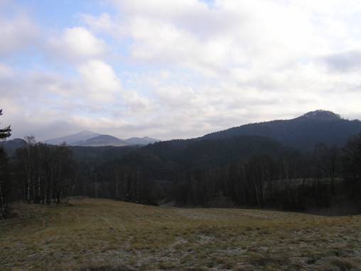
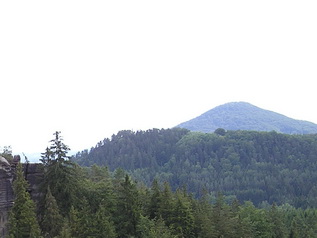
Another place that is is quite surprising are the meadows placed high above the slopes of Hrazený (608 m a. s. l.), along the green trail that leads here from the east by way of beautiful forests, from the streams of Mandava, or in conjunction with the red trail coming from the train station in Brtníky. The majesty of the beech trees that fringe the forested hill of the Šluknovský promontory almost creates an alley leading above the settlement of Staré Hraběcí, again one of the places with once-in-a-lifetime genius loci. The view of the mountains from the meadows to the south, on the range of Tanečnice, and the peaks of České Švýcarsko, rising behind them with the dominant Růžák and Sněžík mountains, is both unknown and surprising.
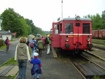
I have already recommended the Thieves’ Path above Mikulášovice many times. It used to be the connection from Tanečnice via the ridge over Hančlův Vrch, further to the settlement of Kopec and the Kyjovské Valley or to the ravines of Bílý Potok. There also used to be long-distance trails connecting Horní Lužnice and České Švýcarsko. Nowadays, the ridge pathway is barely visible. However, its vistas are still worth it. The best way is to get off at the station “Mikulášovice Main Station (Mikulášovice horní nádraží),” where you are almost at the highest point of the railways. The train station is unsightly, but it is enough to walk a few hundred meters and ascend to the meadows at the top of the tableland. Here, from a height of 500 meters, you will discover the gradually opening panorama of Vlčí Hora, the Lužické Hory, Studenec, Růžák, and Středohoří. In the foreground, you will be able to observe Bílý Potok Valley and the outlook on Weifberg. From here, you can wander further along the Tanečnice ridge further to the touristic trail that leads to Saské Švýcarsko over to Hinterhermsdorf or Saupsdorf. Those outlooks are not so famous today. However, they are still “ours, ” from the side of Šluknov promontory, and they are without error, especially before the setting sun in Autumn and the wintery seasons.
All of those places are connected with the above-mentioned railway, whose operation is scheduled to be radically reduced. If that is to happen, it will be a great pity, for it is the only railway that enables entrance to České Švýcarsko from the north, especially when the entire region is becoming a sought–out destination, thanks to the many awards that have been awarded especially in the area of tourism.
More than a hundred years after its existence, the trail now part of the surrounding landscape, it is once-in-a-lifetime with quiet beauty, where we can only imagine the closeness of the rock formations near the Křinické Valley with its ravines and renowned boating.
Come here if the trains still run regularly and if you are not indifferent with the destiny of the railway, then show interest in your villages. In life, it is worth fighting things that seem to be insignificant when we truly convinced of their sense. It is imperative, especially in today’s catastrophic and unconcerned times.
 In the Šluknov area, there is a whole range of places that are in the shadow of known the touristic destinations of České Švýcarsko, yet still open the path to journeying along, for instance, Horní Lužice to the territory of Upper Lufthasian houses and observation towers. The new map of this area, Šluknovsko 1: 25,000, which was published by Krásná Lípa tourists last year, will help us orient ourselves and reach the most northern point in Czechia.
The starting point of our journey can be Lipová, Liščí, or Severní. The shortest way, however, starts in Germany at an isolated boarding house and restaurant Waldhaus on the road from Steinigtwolmsdorf to Neustadt. There is a small parking lot (opposite of the restaurant building across the street), and from it, we can continue to the south following the forest path right to the border crossing less than a kilometer away. To orient ourselves, we can use the signs saying Nordcap. After a little while, you will arrive. The border path goes through a dark forest, and at one place a German information sign, will provide you with the following information:
“The journalist and amateur sportsman, Petr Stache, who passed away in January 2006 at the age of 66, described his trip to Nordcap at the beginning of the summer of 2005 in the newspaper SaechsischeZeitung: “Only a white post at border stone 2-40 marks out the most northern point of the Czech Republic. It lies at latitude 51°3’20” N. Here is the most northern point of the former Austro-Hungarian Monarchy and the now the Czech Republic. Nowhere in the Krkonoše or Krušné Hory, does Czechia reach so far into Germany.”
The border path leads to the west through an overgrown forest where we can see many old beech wood trees, over the mountain that was named after them, Buková Hora (512 m a. s. l.). It is good, though, to return to the Waldhaus restaurant and follow the signs to the mountain Valtenberg (587 m a. s. l.). It is about four kilometers, but definitely worth seeing.
Valtenberg, along with Tanečnice, and Unger, form a triplet of mountains that are crowned with historical outlooks. The one on Valtenberg is from 1857 and is architecturally constructed in a very modern style. Its large windows remind us of the House of České Švácarsko in Krásná Lípa, which was constructed 150 years later. Entry to the tower can be purchased in the nearby restaurant – do not miss it.
In the book “The Most Beautiful Views of České Švýcarsko (Nejkrásnější výhledy na Českosaské Švýcarsko),” I described panoramas that reveal themselves from Tanečnice and Unger. Valtenberg is found some kilometers to the north, the sandstone, rocky landscape does not dominate the southern view; it is hidden behind the mountains as mentioned earlier. The outlook is quite vast over the Lužické highlands, Krkonoše, and Colmberg in Saxony. It reaches to the town of Budyšín, the mountain Stolpen, Milešovka, Děčínský Sněžník and even to Krušné Hory.
The walk back to the car leads through calming autumn forests. After the 10-kilometer long trip, we will drive through the reconstructed villages Horní Lužnice, that will give us a notion of how the communities of the Rumburk and Šluknov area looked in the first third of the 20th century. The undulating landscape is so different from the chain of the conical peaks in the Lužické Hory and Středohoří, or the cloven rocks of the Děčín Walls – they inseparably belong to life in Northern Czechia on the boundary of Lužnice. Here there is still much to discover for yourself and your closest and those closest to you. Buses full of tourists will likely never come here, and I think it is probably a good thing.
 I always love to visit my dear friend M. N. with his charming wife J. in Rumburk. In their modesty, they do not want to be named, and so I will respect that.
During my occasional returns from the Ural, I love to visit their hospitable home and garden; it is always a balm to the soul. In April, for instance, while snow still covered Russia, everything in their garden was in bloom. I felt as if I were in the Mediterranean and only the sea was missing. However, the exceptional coffee and “koláčky,” as only J. knows how to make, accentuated the atmosphere of the place. It was truly like in the Greek tavern Populodopulos in Iraklion on Crete.
Before our Sunday morning cup of coffee, M. and I always go for a short or long run, usually an hour long. M. is athletic and always exhausts me, but most of the time, I bravely keep up - at least for the first half of the run. Still, I make my way to them about once every two months.
During those largely morning runs, I discovered the hidden charms of the near and far surroundings of Rumburk. It is a little bit shameful; As often as one visits České Švýcarsko or the Lužické Hory, one often forgets what can be seen in one’s own backyard.
I was most surprised by Jitrovník. We ran up through Království , following the yellow trail to its peak. The beech trees were a bright green, and from below, new points of view opened up before me. I could see Vlčí Hora, Plešný, Dymník, Jedlová and Luž in a completely new perspective. Then, we ran the footpaths down to the German border through the mountain forests, down to Černý pond. It is a corner like somewhere in Šumava; from our side, practically no one comes here, still yet crowds of local tourists pour along the local pathways coming from Saxony.
Then we ran directly along the border stones to the East towards Jiříkov, then upwards again, through the forest along the ridge to Království. After five more long kilometers, our morning cup of coffee was waiting for us.
The same day afternoon, we went with a group of friends on Studenec and Jedle at Česká Kamenice. It was a beautiful Easter trip. Only I, on the return trip on the train, did not admire the beauties around Kytlice and Jednolá as I fell asleep. Nothing should be overdone. The morning run and the afternoon hike did their best and vanquished the after the body’s weakness that follows winter. Well, tell me what you think: Is it so much to fall prey to an entire day of motion in the fresh air of our mountains, when, during the previous, long, Russian winter, you were getting used to the Siberian frost?
 All of the previous trip recommendations from Jiří Rak can be found on our website under Tourism and Recreation tabs.
The last Sunday in June was no different from the previous days – thick clouds, threatening with heavy rain, the warm summer was nowhere in sight.
On a beautiful meadow at the cottage U Šámalů on the Ještěd Ridge, a broad perspective opened before me, despite the cloudy weather. I could see far into the Czech interior and to Jizerské Hory; it is one of the most beautiful views I know and, believe me, when I say, I have seen quite a lot.
It is not a very difficult hike – if you go from Ještěd to Javorník, you won’t regret it. The association for Jirezské Hory and Ještěd has built cottages and trails connecting the most beautiful places to the observation towers in Český ráj, Bezděz, Ralsko, Liberec Basin, Černá Studnice and Krkonoše. Like on a plastic map, you will see the main destinations of the Jizerské Hory: Rálovka, Ptačí Kupy, Holubník, and Jizera. All of this can be seen in the unbelievable transformations of the mountain range when you descend through Pláně, across the meadows at Prosečský hřeben, towards Javorník. Half of a century ago, a restaurant that was well-known wide and far called Obří Sud burned down here. Using the gondola from the top of Ještěd and from the train back, say from Hodkovice to Liberec, it is one of the most beautiful trips in Northern Czechia.
The cottage, U Šámalů, bore witness to my friends’, David Patva and Dáda Pýchová’s, wedding. The double abbreviation DP (when the bride took her new husband’s last name) in this case doesn’t stand for Dolní Poustevna or “dálkový pochod (long procession)."
We all stood in the meadow in a semi-circle around the granite seat, where the councilor from Český Dub performed the ceremony. We wished them a successful life, in not only the territory from České Švýcarsko to Liberec but everywhere they live and work.
Imagine the atmosphere: high in the mountains, the scenes on all sides and more so, the celebration of the joining of two lives.
The bride’s dress stood out against the steely clouds. The meadows had blossomed, not unlike those in Krkonoše, a mild breeze from Poland ruffled about, and from the Jizerské Hory, heavy clouds above us crept towards the mountain range. At soon as the newlyweds shared their first marital kiss, the clouds poured rain on the entire meadow.
The weather was not able to spoil the loveliness of the wedding. Lunch took place in the beautiful cottage U Šámalů, where the walls bear many old pictures, reminding of the fame of touristic groups from the times before the Great War. We had true Kendlíčková soup and homemade svíčkova – they were among the best experiences of the day. Maybe not for the married couple, as they were joined together with a white scarf and had to feed each other from a large plate, according to the Czech tradition. It was quite amusing, but a bit uncomfortable when eating.
In the afternoon, we relocated to Libverda, where the matrimonial merriment set off in full swing, even with the portent of the rain so common for this June. Even the rain could not prevent the bride from being kidnapped, but the opposite: Searching for her in the darkly forested surrounding mountains and in the remote corners of the Frýdlant Promontory was very painful for the groom. He looked late into the evening but eventually achieved. He found his wife in a broken-down car and, after obtaining gasoline (very thrilling, neighboring petrol stations were closed in the evening), escorted her back to the whirl of the wedding merrymaking.
One evening in June last year, DP, DP, and I stood on top of the granite rocks of the Frydlant battlement, after a great mountain hike around the Black Brook waterfall and the narrow path from the rock towers of the Hájní Church. The towers of the pilgrimage tower in Hejnice sparkled deeply beneath us in the light of the setting sun, a diesel train wails in the Smědá Valley. At the time we did not know that a year and a day later, at practically the same place at the nearby Spa in Libverda, their wedding would take place. In the beautiful region of the northern Bohemian mountains, as of yet little had been rediscovered for tourism.
And like the Ještěd ridge, even the northern slopes of the Jizerské Hory with beech forests, the largest in the Czech Republic, the rocks of the Frýdlant battlements and Ořešník, and the wild gorges with their waterfalls offer countless beautiful hikes from Hejnice and Bílý Potok. Good walkers can go across the mountains to Liberec if they like.
 The western part of the Lužické Hory gradually descends into the sandstone gorges of České Švýcarsko. Above them, settled on the slopes of the unforested Křížový Vrch, is Rynartice. We can find a unique, distinctly mountain scenery, which has enhanced the apparent closeness of the massive Studenec, the most dominant of the surroundings. The closeness is really only apparent, because Rynartice, one of the most beautiful villages in České Švýcarsko, from the spread-out group of Studenec, is separated by the deep valley of Chřibská Kamenice. The ascent to Studenec on this side, through Studený, another unforgettable settlement, is difficult and long, but it is an unforgettable tour in northern Bohemia.
The first time I had traveled to Studenec from a different side, from Ceská Kamenice through Jehla and Lísku. I could not have chosen a better starting point for the tour: I descended from Česká Kamenice by train engine through Prácheň and Kamenický Šenov to the českoamenické train station, a few years before the abolition of one of the most beautiful tracks in Czechia. Regrettable: Nowhere else have we shut down so many local railways, not in the previous nor the current regime, as we have in Northern Czechia. We like to boast uniqueness České Švýcarsko, Lužické Hory, Středohoří and Šluknovsko - and yet so few are doing anything to preserve their originality.
It was April, a clear spring Saturday and the beeches above Lísku were still completely bare. Throughout the climb, I did not meet a single sightseer. At the top were still quite a few distinct remnants of touristic cottages. The old tower was already, in the early seventies, very rusted, I expected it to fall over very shortly. I did not then believe in its renewal, and today I admire that it has withstood and endured the ravages of time for so long. Unlike the train of Ceská Kamenice, the tower has lived to see it. It has excelled this year (2009) and again it stood, in all its glory, even though the fight to save the tower was fierce, and those who were instrumental in it will never express the measure of effort that had to be invested.
For the first time, I saw the Studenec on the western horizon, where the Elbe winds into the German plains, the mesas in Saské Švýcarsko. These beautiful, massive rocks are visible in Českoamenicka from many places, and yet, people practically do not know about them. From Panské Skály, Hranáče, from the slopes of Ovčacký Vrch, the meadows above Líska, from Klíč, from Větrný or Pastýřský Vrch at Růže, all of these places are among the prime tourist destinations in northern Bohemia.Yet the view from Studenec is unique. Unique in-depth. From a height of 733 meters, you can see not only the mesa, but sometimes the dominant Růžák far below, as well as the jagged landscape of České Švýcarsko, and you have such a direct, textbook view of this rocky region.
The view is best from the stone sea of the western edge of the spread-out top of Studenec, photographers have not yet discovered much of the sunrises here.
Studenec, however, is not known just for its views.
The beech trees on Studenec, the most beautiful trees of the region, evoke the mood of staying in an old temple. As massive columns, they rise at ample intervals so that you can admire their strength and how broad they are. Their special charm excels in November when from between their bare trunks, shreds of mist begin to wash out, spilling over the top of the hill. These are then gently torn up, and lightly the faint sun illuminates the old path.
Roads, another peculiarity of Studenec. The beautiful journey through the red ridge from Jedlová through Studenec to Jetřichovice, wandering the dreamy landscape, is still changing its shape – from the forested ridges to the abysmally deep rock valley of Chřibská Kamenice.
Deer and chamois at Studenec. With luck, a herd of several large deer will run close to you along the edge of the meadow in the seat under Studenec. You may jump in surprise, but to the beautiful animals, you are not worth a glance. And a few chamois, the inhabitants of this beautiful alpine environment, graze nearby.
It is evening in Studenec, time to return. Just as in the ancient times in April. Around the houses in Lipnice, it is almost completely dark, you come to a meadow overlooking Černý Kámen, the most mysterious and most extensive table mountain of Saské Švýcarsko.
I then walked further around the former Grieslův mill to Jetřichovice. I felt that I was failing the magic of the whole rocky landscape, controlled just by Studenec from the East. I knew then that I would come back here many times. I wanted to quickly identify the locations on both sides of the border, to understand something of the distant past. I recognized the region well within a few years. The people, unfortunately, haven't until recently, after three decades since my first visit to Studenec and other places. I was lucky enough to meet them daily, work with them, share their stories.
I would like to thank them sometime, that they accepted me as one of their own. The mountain itself and the entire region were initially inaccessible, and finding a way to them was not easy. Today, I now have among them a wide range of friends.
The road disappeared. I force my way through a thicket on the far Urals and walk on the cliffs, mountain pushing about as high as Studenec. The endless sea of forests and rocks between Europe and Asia on the imaginary border between continents, most yellow bruises in my life. October evening, late in the Indian Summer, when distant Bohemia is overwhelmed with heavy snow. An inverted world. The time for me to return has not yet come.
 At the time, I came to the maze of the Tkalcové and Soucovské ravines on the German side behind Pravičká Brána for the first time. It was early spring, as in those days, a lot of wet snow still laid in places in the ravines, but on the rocky ridges of Thorwaldský Walls and Jortanshorn, it was dry and warm. Old hiking trails were then still clearly visible. Carved steps and remnants of handrails showed that many decades ago showed that promenade routes like at the rocks of Schrammsteine and Affensteine on the other side of Winterberg.
Silence and Reverence were over the rock mines. From the amazing cave Webergrotte, the rocky path climbed up the ridge. It didn't seem believable that Pravčická Brána is only two kilometers away. In the maze of ravines nobody expects that high above the border trail opens an unobstructed view to the south into the interior of Czechia.
And yet this is so: The most beautiful section of the Czech-German border is full of contrasts. It has lost something of it's charm since that time. The old paths are forgotten, foul concerning nature conservation, and now a visitor is an unwelcome intruder.
I came across the rocks to Zeughaus, an old village, hidden in the cuts of the valley through Velký Zschand. The garden restaurant that is now at the historic house from the 17th century was not there yet. The massive building has marred the settlement, the convalescent home of the East German unions today no longer endures.
I found lodging with the gamekeeper Steiner, whom I had later met several more times. He is one of the greatest experts of the rear rocks. Later in the evening, a member of the East German police in a leather uniform came to the game warden's lodge. He checked my passport, the guard saluted and disappeared into the darkness.
At night, through the window, I watched several burly boars stomping around the house.
In the brilliant morning, I set foot on Teichstein, Rymbičký Kámen, one of the best vantage points in the Křinice. Above the shreds of morning mist, the cliffs of the castle of Zadní Loupežný, Winterstein, sailed like an ancient boat. The walls of Little Winterberg were illuminated by the morning sun. After that, I had never again experienced that picture like that.
That day I continued still to the massive rocky double arch of Kleinstein, reminiscent of the huge Gothic portals of a cathedral. Already after dark, the empty wagons of the old tram in the Křinice Valley took me to BadSchandau. This boxy car from the early 20th century was used even before the current, postwar-era trams.
The rocky landscape of Big Winterberg, the most beautiful mountain, was plunged into darkness. Saské Svýcarsko, frequented even by the GDR, was rarely forgotten by tourists in the early days of spring 36 years.
Half life, long forgotten dreams. And yet - one can never forget the images from the first visit to those places. But even today, there is somewhere to return to - in the good times, it is possible to reach the mountains and rocks without people. Another world. Landscape, shadows and light. Unknown stories, forgotten church trails and forgotten residents. Secret. The night of March.
 Many spectacular landscapes are in northern Bohemia, both that within our country and in Europe, do not have competition. They have always talked little about them during the time after the war, tourism had not developed at all, but even in the last 20 years, the sites along the border have not been paid much attention. Except the traditional targets, such as Pravčická Brána.
We are lucky that Krásná Lípa is located in the heart of the region, which has no equal, and it would be good if we were aware of it, especially at the present time when not everything is not very happy. The natural treasures of northernmost Bohemia directly surround us, they are countless, and it distinguishes us from other regions of the country.
Krásná Lípa, with her sandstone landscape of Saské Švýcarsko, joins the Křinice, and their beauties are in fact not so well-known. The Kyjovské Valley is well known, especially since a popular bike trail leads there. And then, in the places where the Křinice becomes a border river, the gorges start, which even in its neighboring surroundings offer several unique places that escape the attention of Czech visitors. They are places, usually a few meters beyond the German side, in an area that is, for us, somewhat remote, but definitely worth seeing.
Around the former Zadní Jetřichovice, where the Křinice (and thus the borders) exceed the trail from Vysoká Lípa in Hinterhermsdorf, the former historic connector, also know as the Czech Path, which was functional in the 14th century (both of these villages can be reached by car and have a parking lot), today, one of the most remote corners of the National Park of České Švýcarsko with a minimum of hiking trails. Even still, the German side roads are marked, yet not very frequented, and lead us to many hidden objects.
The towering rock wall on the right bank of Saxony above Zadní Jetřichovice is called Rabenstein (Raven Stones). The green trail leads to them. After climb steeply for a while, you come to the edge of the rocks, 60 meters above the valley. A great view of the meanders of the Křinice is not offered to such an extent anywhere else. Only here you realize the beauty of the river and its valley, the steep forested hills and rocks. We can see from here to Růžák and Raumberg, significant volcanic peaks that are characteristic of this landscape.
From the trail, it is possible to go to the thick forests above the Křinice on the crossroads of Wettinplatz and continue to the Hinterhermsdorf or to the gorge of the Křinice with boating on the rowboats of Ober Schleuse.
Another destination is practically right on the border (though also on the German side), in the hard to accessible Kozí Důl – it is completely inaccessible from the Czech side. An inconspicuous green symbol, in the shape of a triangle category, Bergpfad, mountain trail, leads us there. It is a bit more challenging than the normal trails, but for the average pedestrian, it is not a problem.
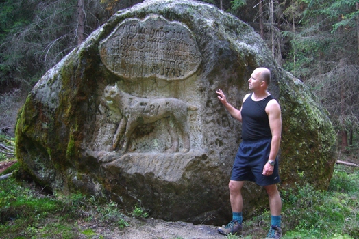
Less than a half a kilometer downstream of the Křinice from Zadní Jetrichovice, (both banks of the Křinice are now German) the path turns left across the bridge over the Křinice green in the direction of Altarstein, Zeughaus. The path rises through the shady ravines of Brueckengrund, and it must not be overlooked that the triangle that leads us to the left of the ravine, first up and then down, sharply downward to Kozí Důl, is a surprisingly beautiful, peaceful place in the heart of Zadní Českosaské Švýcarsko. We stand in the deep forest at the border that we, without the milestones, would never have noticed. In the solid block in the shadow of the low spruce trees, we can see a relief of a lynx and above it a German inscription declaring that in 1743, the Forester of Hinterhermsdorf, Johann Gottfried Puttrich, shot a lynx on this spot. It was a time when lynxes in Saské Svýcarsko were already very rare. The last one was shot on the Czech side, probably in the late 18th century.
The two above tips do not cover all of the places around the Křinice in the area of the state border. Visiting the two can merge into one trip – that's a good program for the day, especially if we go to Zadní Jetrichovice in Vysoká Lípa. It is not unreasonable to go along the Czech Path on a bike (the bike trail in the national park), it is necessary, however, to hide the bike well after – leading to both site are only trails of the mountain variety.
Visit these places in the oncoming autumn, a time of colors, falling leaves, and fog. You'll be surprised at what beautiful places are offered around the Křinice, the rocky river that their valley opens into at its beginning, at Krásná Lípa, and the entire way it doesn't leave the forests until it reaches its mouth at the Elbe in BadSchandau.
The last two pictures in the article "To Rysí Kámen at Zadní Jetrichovice," provided by Martin Rak

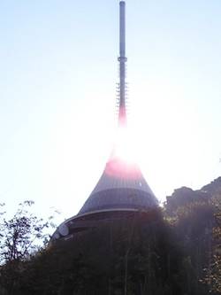
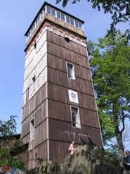 A lot has been written about it. The Köegler Trail now leads over it; at the beginning of May was celebrated the 120th birthday of its observation towers, perfectly maintained by the Krásná Lípa Czech Tourist Club. Attendance was relatively large in recent years, but it has not rubbed away the charms of this monument of Rumbursko, which, being highly elevated on the edge of the Lužická fault, above a sandstone slab of České Švýcarsko. It is the real crown of this part of North Bohemia.
Try to reach the summit of Vlčí Hora on a clear day in the morning (the lookout tower is open during the summer from 9 am). Just barely can you see the rocks of Saské Švýcarsko in the sunlight and become aware of the contrast between the "sunken" land of ravines, valleys, canyons, and the protracted, rolling ridges of the Lužická range with Plešné, Hrazené and Kottmar.
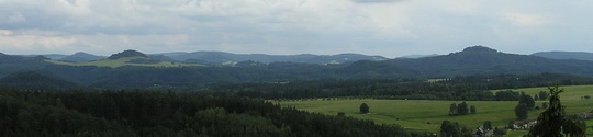
The immense wealth of forests at the rear of České Švýcarsko, the crest of the Lužické Hory, the dominants of Růžák, Studenec, Jedlové, Luže complement the soothing curves of the meadows around the small train station in Panský. In the distance we get a glimpse of Hvozd, Ještěd, Jizerské Hory, Kletečná and Milešovka Koenigstein and Lilienstein. It is truly the original local railway junction in unspoiled nature, yet it maintains regular operation of several motor railcars per day. Not even the nearby view of Rumburk can interfere with this precious natural image, which does not differ practically from that which greeted our ancestors, from the viewing tower at the time of its creation. The remote sandstone table at Děčínský Sněžník is also unique, a large black stone, reminiscent of the massive walls of ancient fortresses.
It is worth noting that another direct connecting line of so many great vantage points on the border between Saské Švýcarsko and our promontory: the rock Koenigsplatz over the Křinice Valley, the old village Hinterhermsdorf with meadows on the mountain ridge, the lookout at the cumulous Weifberg and the tower on the steep Tanečnice ridge. All of these great attractions are so neatly aligned just right when viewed from Vlčí Hora.
This year, spring came in like a rocket after the rich winter snow. At Easter, the old beech forest on Vlčí Hora already shone a bright, light green, which otherwise takes control around early May. There are not so many beautiful places in the Czech Republic as in the landscape under Vlčí Hora, a region with an ancient tradition of tourism and old roads, which are now often forgotten. Exactly at spring these paths came came alive, linking in many directions the valley of upper Křinice, the Thieves' Path, the area of Plešný, and the mountain park with rhododendrons in Karlovo Valley at Šluknova, in the footsteps of the then predominantly Saxon tourists. Today, the atmosphere is mostly completely silent, seemingly undisturbed by civilization.
And the view from Vlčí Hora enables one to empathize with the compositionally flawless panorama of the landscape that surrounds us here. If we see just a little of the beauty of this world, just a little, at least here we can feel uplifted over artificial problems, above party antagonisms and unprofessionalism and petty people who assume the right to decide for us.
By keeping a straight, deep relationship to one's region and its nature is one of the few ways to maintain an honest, principled attitude, with common sense and insight. Oddly enough: conservative classical tourism (not connected to artificial outdoor achievements that dehonestují traditional mountain areas), which still uses the old huts, prospects, and paths, built with incredible feel for the landscape, make this possible.
And that is the mission of Vlčí Hora and the old lookout tower.